
I’ve always been interested in alternate electricty sources but only really dabbled on the periphery.
When we lived on the hill in Raurimu, we thought and thought about maybe using the water drop to spin some spinny things to generate some power and even went as far as buying a chunky wind turbine off TradeMe (still sitting in the garage!).
One face of our very steep pitched roof faced north and probably would have been ideal for solar but it always seemed too expensive and too hard – honestly, probably just feel in the too hard basket.

Cut forward a few years since ANZ Aotearoa screwed up our forever home plans and we went our separate ways. I stumbled across YouTube as a streaming source and soon got a few links to Gav Shoebridge and the Ecotricity NZ channel – to be totally honest, I was working in Te Kuiti at the time and Gav lives in Te Kuiti and that’s probably how the algorithms made the connection.
Gav is the world’s very best advocate for E-anything. When he solarised his home late last year that lit the slow fuse for me. Specifically once he got his first power bill:
The first part of this year was pretty intense for me so I didn’t actually get round to making an inquiry til the beginning of June. I had had several friends try to sign me up with SolarCity but I was never quite comfortable with the concept of renting something that is permanently attached to your home and the potential complexity if you sold that house…just seemed like too many working parts and then SolarCity went bust so that was the end of that…
The other company that Gav got a quote from was Endless Energy so I just made my first inquiry with them. I could have cast the net wider earlier but I figured I’d start with Endless and see where it went. They responded to my online inquiry the first working day after I submitted it.
Apart from the address, the only info I had to provide was a recent power bill that showed my annual consumption. Quotes for options with and without batteries arrived in two days and I liked the numbers. I’ve opted not to go for a battery at this stage and only gone for the the recommended installation. It lefts me with a lot of eligible roof space if I decide to expand the system.
I decided to get a Green Loan @ 1% from my bank and that process was pretty smooth apart from Docusign refusing to work on any of my devices. The time from final approval to loan drawdown was a couple of days. As soon as the loan was approved, I accepted the quote and made the deposit as soon as the money was in my account.

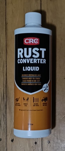
Now, my roof is old(ish) and original – I had thought of repalcing it but it still functions as advertised with NO issues. Endless Energy recommended spraying the section where the panels are going to be, with 30 Seconds Roof and Awning Cleaner and then paint CRC Rust Convertor Liquid on to the nails to extend their lives…

Both actions will happen as soon as we get a dry day that I am not working: hopefully tomorrow- I even brought a new hose to eliminate any logistic issues.
So now, I’m just waiting for Endless Energy to come back to me with a date for installation and away we go…


 These apples were dumped at the side of the lookout car park. Sure, they will eventually break down but that still doesn’t making this blatant dumping OK…


