This image is taken from the NZ Herald story this morning confirming NASO plans to discontinue rescue helicopter services from Taupo and Rotorua. It is credited “This Ministry of Health image illustrates the 95 percent coverage from bases that currently provide services.”
It is misleading, perhaps deliberately so…It implies that this coverage is provided from the bases (red dots) shown on the map but omits the two bases in the central North Island at Taupo and Rotorua. Only the blindest of the blind could not see the bright smudge in the centre of the North Island that represents that Taupo rescue helicopter’s main operating area i.e. Tongariro National Park, Tongariro Forest Park and the Desert Road.
…but you have to be a registered supplier to actually access the tender documents…so much for open government…
More and more, this reeks of a bureaucrat-driven efficiency plan under the guise of ‘government’…
Rescue helicopters based in Tauranga, Palmerston North, New Plymouth and Hamilton cannot adequately service the Taupo and Ruapehu dependencies as well as their own.
They are already busy enough
Their response times, assuming availability, are too long.
They lack the intimate knowledge of the Ruapehu area that makes the Taupo rescue helicopter so successful.
Any presentation to the contrary is misleading and dishonest. Even if the numbers of helicopters at those more remote base locations are doubled, that does not address the issues of response times and local knowledge.
The Herald reports the following rescue helicopters stats from 2017:
Hamilton – 654
Palmerston North -286
Taupo – 237
Rotorua – 229
Tauranga – 203
Does NASO seriously expect Hamilton, Palmerston North, and Tauranga to absorb another 450+ flights each year…? Seriously…?
Visit the petition page. Read some of the comments. See how many lives have been touched by this vital and proven life-saving service.
When someone dies because there is no rescue helicopter, who carries the can? Not some faceless gnome in NASO, that’s for sure…
It never stops…the National Ambulance Service Office (NASO) is operated by the Ministry of Health (MoH) and the Accident Compensation Corporation (ACC). We learned this morning that the Taupo rescue helicopter has been excluded from the list of air ambulance services to be provided by NASO from November 2018. The Rotorua rescue helicopter is, apparently, also off the list.
This means that air ambulance services for the Central North Island will now be dependent on helicopters based in Hamilton, Palmerston North, or New Plymouth; in extreme cases, support may be available on a longer notice to move from 3 Squadron, RNZAF, based at Ohakea.
Even cross-country, and assuming they are not already tasked in their own districts, there response time is considerable longer than that of the Taupo rescue helicopter. The crews of these other helicopters, no matter how capable, lack the same intimate knowledge of this district that enables the Taupo crews to slip in under the weather to pluck off the injured and infirm.
In some cases, this local knowledge means that the Taupo helicopter will be the first responding ‘appliance’ on the scene in isolated areas with challenging road access…often providing the confirmed location that allows those other services to navigate their way to the scene.
I could not count the number of emergency responses that I have been involved in over the four plus years since I started to work here where the Greenlea rescue helicopter has provided critical support and saved lives.
To protect this vital and proven life-saving capability, we need to reshape perceptions in the capital. At the moment, one of the lost effective ways to do this is to contact the Members of Parliament in the affected districts:
It pretty much speaks for itself. It looks like some efficiency-driven initiative that will have a massive impact on the Ruapehu and Taupo districts – I also understand that the intention is to no longer support the Rotorua rescue helicopter as well.
The Taupo rescue helicopter provides and vital and proven life-saving capability in the Ruapehu and Taupo districts. Helicopters from other areas like Palmerston North, New Plymouth and Hamilton are already very busy and their crews lack the intimate local knowledge necessary to operate in and around Tongariro National Park. Gone are the days when we could rely on a timely intervention from a RNZAF Huey, when civilian rescue helicopters are not available or cannot operate due to the weather.
It would be much appreciated if you could express the views of this community to colleagues in the Ministry of Health and Accident Compensation Corporation and promote the retention of this vital resource.
No one else will fight this battle for us. Email, Facebook, Twitter etc all give us the tools to stand up for ourselves. The loss of the Taupo rescue helicopter doesn’t just affect us who live here, it has negative implications for everyone who passes through Ruapehu and Taupo.
Let’s keep this flying…
Edit: Just in from Phillips Search and Rescue Trust, that operates that Greenlea Taupo rescue helicopter:
“Thank you for your expression of support for the Greenlea Rescue Helicopter.
Philips Search and Rescue Trust, operators of the Greenlea Rescue Helicopter, intend to fight to retain the base for the people of, and visitors to, the Taupo and Central Plateau region.
Taupo’s local MP is Louise Upston and you may like to write directly to her in support of retaining the Taupo based rescue helicopter service. As this is a Central Government issue you may also like to write to the Minister for ACC, the Honourable Iain Lees-Galloway.”
There you go, folks, the ball is in your court if this impending loss affects or concerns you…
First up, Stuff.co.nz, it’s not a two hour plod and that comment itself is disrespectful: it’s a proper climb in an environment that is not forgiving. Mt Ngauruhoe deserves respect for that alone.
Secondly, referring to Mt Ngauruhoe as Mt Doom is equally disrespectful; more so when the request not to use this reference is a specific part of this summer’s campaign.
Thirdly, the Tongariro Alpine Crossing is not a “…20-kilometre journey along one of New Zealand’s nine Great Walks...” The TAC is not actually one of the nine Great Walks at all, although it shares part of the trail with the Tongariro Northern Circuit – which is one of the nine Great Walks.
I mean, really…? Did you even think about this before publishing it…? Even after the scorchings you have had for similar errors in the past..?
Mt Ngauruhoe, as with the two other summits, should be respected for its cultural significance. Some days it looks like an ant nest with unprepared visitors swarming over the north face. Just because they aren’t man-made structures (like pick a famous church) goes not mean they are worthy of any less respect.
People will still climb them – that genie is long out of the bottle – and the challenge now is to shape their behaviour towards one of greater respect. Being safe is part of that respectful behaviour: there is a risk in placing rangers to discourage visitors from the most popular route up the north face. This is an action that DOC specifically stated it would not take at the public meeting on this issue in Whakapapa two weeks ago.
That risk is that, by discouraging people from the most popular and safest route up the lave ridge on the north face, DOC will be encouraging them to select other routes. These other routes won’t be, for the average visitor, as safe as the north face route. In addition, the concentration of most climbers on the north face means that the very clear start point for search and rescue operations on Mt Ngauruhoe may no longer exist and that visitors in distress may be on any one of a number of less safe alternative routes.
Concentrating visitors on to one route or area also minimise the visitor impact on other areas of each mountain. That impact is not just the literal impact of pairs of feet, but of human waste (ewwww), rubbish, lost gear, and walking poles (each pole is like another foot striking the delicate volcanic surface).
The situation is aggravated by publications like Wilderness Magazine advocating alternative routes without differentiating them by risk or difficulty level, or information centres, with the best of intentions but perhaps not the best knowledge, recommending routes based on what looks OK on a map, or second-hand unvalidated information from other visitors.
In a perfect work, we could all sit back and enjoy Tongariro and Ngauruhoe from afar, respecting their significance to local communities. But we’ve over-hyped and -marketed the Tongariro Alpine Crossing for decades – and all involved need to share responsibility for this. We need to look to the future though – leave the past behind – and consider how we ALL can best play our “…guardian role in protecting not only Tongariro and his peaks, but also the safety and wellbeing of visitors to the region…?”
This will only work if we do this together…
…to sow the seed of visitor expectation as soon as there is the faintest glow in the light bulb of “Let’s go Tongariro“
…to must be consistent on our messaging and at time put aside, direct personal benefit…
…to make visitors feel welcome and safe…and informed…
Token creature…first one I saw in the image archives…
Been a long but satisfying day…
Louie and Kala went for their first ride sharing the back of the truck together with no major arguments – OK it was just to Lower Raurimu and back – so that’s an important milestone out of the way…
Picked up an old deck chair to restore – hence the visit to Lower Raurimu…
Learned how to make onion rings on an industrial scale…
Was a creature of habit in opting for fish’n’chips for dinner when i had the whole menu to choose from and there are still things I haven’t tried yet…
Was reminded not to pass up the opportunity off a meal when it’s quiet because quiet may not last…
Enjoying this hospitality gig…great to be busy and learning again…
1. “Hikers will have only four hours to do the 19km trail” Wrong! The 4 hour time limit for parking is to allow visitor to the park to do some of the shorter walks from Mangatepopo car park. In addition, any intimation that the Crossing is doable in 4 hours is simply irresponsible – yes, I saw the note about the normal times – first responders up here do enough rescues of people who can’t get their timing right already.
2. “Hikers can alternatively park at the Mangatepopo car park and then pay for a shuttle to the start” Mangatepopo IS the start of the Alpine Crossing.
3. “…at a cost of $30 per adult and $25 per child….” Where did these figures come from? The cost per adult ranges from $25-40; children less than 10-12 years old are not encouraged on the Crossing and so many operators do not have child prices. At a guess, this ‘reporter’ has only looked at one site and concluded they didn’t need to look further.
While this initiative is years overdue, it would have been more effective if DOC had not waited until only a couple of weeks before Labour Weekend, the typical start of summer walking, the weather notwithstanding, when many operators have already printed their brochures and accepted advanced bookings.
Visitors are encouraged to catch the buses that will be running from National Park Village every day that the weather permits.
Visitors are also asked to consider starting later in the day to avoid the traditional bubble of people that start the walk between 6 and 9AM. When the weather is good, the Crossing can be started at midday and completed by 8PM with a couple of hours of daylight left (take a torch in case you miscalculate) and if you have made arrangements to be picked up from the finish at Ketetahi.
Mental Health Awareness Week in New Zealand is 9-15 October this year. Each year, the Mental Health Foundation of New Zealand runs and sponsors a number of awareness activities.
We need to see more of the guiding community telling their stories and sharing their experiences on the Alpine Crossing as part of educating visitors to the Tongariro district.
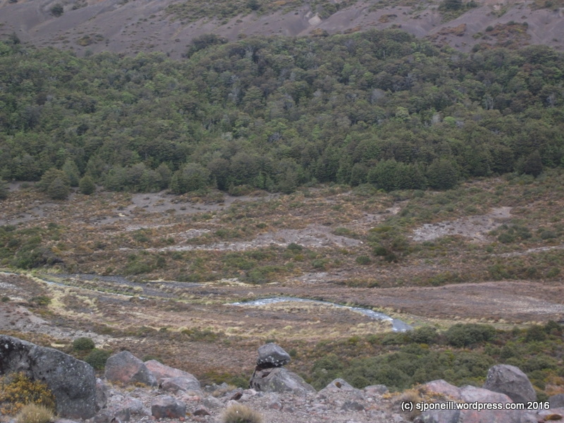
Year-round this is a beautiful place, one of the only areas in New Zealand that you can explore an active volcanic, but it is always a place to be respected. Respected for its cultural heritage and because it is unforgiving towards to the unprepared, ill-informed and complacent…
One of the best sources of current information on the Crossing is the Tongariro Alpine Crossing app that was released this year…available in the Google Playstore and iTunes…is your life, and the lives of your family and friends worth a small fee…? We would hope so…
Get the app…
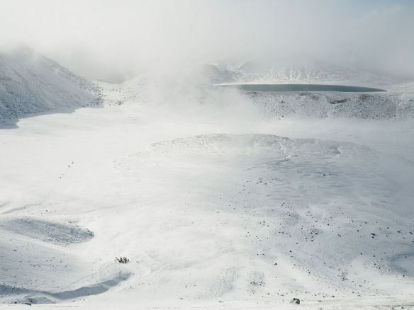
This pic is, of course of the Crossing in summer. In winter, this is what you will encounter:
Yesterday afternoon, I received this email from a good friend who is an experienced guide in Tongariro National Park. The initial target audience was the visitor information centres around the Central Plateau – that audience has now grown…
To whom it may concern,
I am an alpine guide, currently working on the Tongariro Alpine Crossing. This is my fourth season on the TAC. My primary duty of care is to the safety and well-being of the clients on my trip, however I am often asked by freedom walkers for information and advice. Far too many people recreating in Tongariro National Park are uninformed about the hazards on the TAC and are unprepared for the conditions they will encounter. In some cases, people are putting themselves in harms way or endangering those around them and I feel obliged to intervene. This is actually quite common, but most of us guiding in Tongariro see that we act as kaitiake for the people and the land and don’t hesitate to offer assistance. This is an ongoing problem and the number of people putting themselves in danger increases exponentially each season. This is a problem that many people involved in tourism, recreation, and the outdoors community in Central Ruapehu are well aware of.
I would like to make it clear that I am not against freedom walking the TAC in winter, but that I am against trail users getting bad advice or no advice, going unprepared, and exposing themselves to unnecessary risks.
I am writing this letter because of what I saw while I was guiding on the TAC on Saturday, 26 August 2017. The number of people walking the track in completely inappropriate gear with no clue and no humility was SHOCKING. People dressed only in sneakers and blue jeans, without rain jackets or warm hats and gloves. There was a much higher than average number of freedom walkers on the track that day. At a guess, I would say that there were a few hundred. Tongariro Expeditions were operating their transport only service that day, as well as a large number of groups both large and small providing their own transport.
It is my opinion that when transport only services operate in winter, the public is watching. They see “no risk” when in reality there exists a “low risk”. Understanding that difference is critical. It is also imperative that people understand the difference between a forecast and a guarantee. Weather in New Zealand mountains is unpredictable and rapidly changeable. I believe that the greatest danger to people on this day was the weather, and the perceived risk.
The forecast on Saturday 26 August 2017, according to Metservice, called for fine conditions and light winds. On paper, truly a beautiful day! My observations on track told a very different story. The lenticular clouds capping Ngauruhoe meant winds were much stronger than the 15km/h in the forecast for the Red Crater. Metvuw charts showed rain to the northwest of Tongariro, so I knew that those stronger than forecast winds would also bring clouds. In spite of the forecast I could see that we were in for a cold day, with no sun, strong winds, and white-out conditions. Which is exactly what we got. The Red Crater was being hit by 50km/h winds and the wind chill was hovering around -8. Cloud in the Central Crater caused poor visibility, fluctuating between 50 meters and 500 meters of visibility. These are challenging and hazardous conditions.
One unprepared (cold and scared) freedom walker was rescued (from Shelter Rock) by other hikers on their descent from the summit of the TAC and given extra gear and guidance back to the start of the track (Mangatepopo Car Park). People were observed walking on cornices on the Red Crater, walking out onto the ice on the Emerald Lakes, onto the ice on the Blue Lake, and were advised of the dangers they were putting themselves into. Many people without proper attire continued to walk into worsening conditions in spite of warnings from myself, other guides, and members of a local tramping club.
Waikato Tramping Club was on their annual winter Tongariro trek and spent lot of time and energy trying to warn people of the risks involved in trekking in alpine conditions without proper gear or know-how. They attempted to turn around many people on this day that were unaware of the danger they were putting themselves in and unaware of the hazards on the TAC. I have reached out to the club and encouraged them to write a letter with their observations.
I am passionate about the outdoors. I love Tongariro. I love creating safe experiences that are fun and memorable. If I can, I want to help more people come home safe and happy after a day in our mountains. I am reaching out to your organisation with my field observations because I believe that we are allies in this goal. I have provided below descriptions of the hazards, risks and consequences that are common on the TAC in winter, as well as the MetService forecast for the day. I personally observed people exposing themselves to each of the hazards below on this day. It is my sincere hope that this letter is useful in some way.
Thank you for your consideration,
Below is a list of some hazards that exist on the TAC in winter. I have omitted to speak about avalanche hazards, as the Backcountry Avalanche Advisory does an excellent job of detailing the risks and hazards on a daily basis.
Walking on cornices
-large cornices exist around the rim and summit of the Red Crater. There are many others throughout the TAC but these are the cornices that are easiest to walk onto without realizing what you’re doing
-the risk is that by walking onto a cornice you will cause it to break and you will fall
-the consequences of breaking a cornice are VERY HIGH and potentially life-threatening, as you would fall 50+ meters and likely be buried in snow from the falling debris
Walking on the ice covering the Emerald Lakes
-the lakes are not well frozen and are currently thawing, so the risk of breaking the ice and falling into the lakes is VERY HIGH
-consequences of of falling through the ice into the lake are SERIOUS and potentially life-threatening, as both drowning and hypothermia are likely outcomes
Walking on the ice covering the Blue Lake
-the risk posed by walking on the Blue Lake is precisely the same as the Emerald Lakes, but the consequences are higher, as the size and depth of the lake would pose much larger problems for rescue
Not having the appropriate gear
-sunglasses, warm hats and gloves, boots, rain jackets, and intelligent layers are a must in an unpredictable alpine environment such as the TAC. To venture out unprepared is to risk frostbite or hypothermia, or in the case of not having sunglasses you are risking snowblindness
Not having the appropriate equipment
-at the very least it is necessary to carry a topographic map and compass (and know how to use them), the risk is that you will get lost. Poor visibility and featureless snow-fields (such as the Central and South Crater) create navigational challenges. Additionally, the summer track is generally considered unsafe in common winter conditions and an alternate track exists, many people aren’t even aware that they may encounter more than one track and this creates confusion
-often it is necessary to carry (and know how to use) crampons, ice-axe, and helmet. Without this gear you risk sliding down steep and long icy surfaces. Sliding can carry high consequences.
The feelings expressed here are shared by many of us who live up here: as much as we want people to come here and enjoy this wonderful location, we want them to do it safely.
Many of our visitors – and not just the international ones – don’t have any frame of reference for the hazards of an alpine environment…the closest many of them will get is watching Cliffhangeror Everestin FullHD with the woodburner fully cranked up…
Last week, this brochure was released to get the message to national and international visitors to Tongariro National Park. That message is really quite simple:
Know before you go:
Know the weather AND ground conditions
Know what to do in alpine conditions
Know what to do in avalanche terrain
Know what to do when the plan goes wrong
If you don’t know: don’t go – or go with a guide…
A lot of the information online and offered by staff in the hospitality line is well-intentioned but ill-informed. Many people, especially those off the mountain or not ‘mountain’ people, do not understand the hazards of the Crossing in winter, or during bad weather. Many think it is just a case of ‘giving it a go‘, of ‘going harder‘, or just ‘will-powering’ themselves over the snow and ice. Others think that it is more important to promote ‘tourism’ at all costs…
“…the trampers were lucky to escape with their lives…”
“…not sticking together caused the group to inadvertently separate…”
“…All their clothing was wet…they didn’t have it in waterproof packing…”
“…they didn’t call for help until it was very dark and one tramper was unable to walk…”
We don’t say these things, we don’t make the Crossing sound dangerous to scare visitors off, to try to keep the place for ourselves, to discourage commercial operations in the Park.
We say this because we want visitors to come here, enjoy themselves and leave safely.
We say this because we don’t want our people putting their lives on the line for rescues that are unnecessary; being dragged from their beds or jobs at all hours because of good intentions and poor information…
Last day of July, three and a half hours til August (at the time I started typing) and I realise I haven’t written anything all month…
Unmanned aircraft is a subject that I thought I had moved on from but this report popped up in my inbox this evening…only a couple of days after I spoke with a couple of clowns flying a large drone over the Chateau Golf Course in Whakapapa Village. They pleaded ignorance of both National Park and Civil Aviation Agency legislation relating to flying drones in or over the Park but really? You don’t buy and operate a big drone like that without knowing the law.
That law is quite simple:
It is illegal to land, take-off or hover an aircraft in, from or over Tongariro National Park. A drone (of any class or size) is regarded as an aircraft. Any exceptions must have prior formal written approval from the Department of Conservation.
The land-owner’s prior permission is required before a drone can be flown over private land; or the permission from the mandated controlling authority for public land e.g. the local council or, for the Park, the Department of Conservation.
In addition, rescue helicopters can and do enter the Park at any time of day or night, from any direction. Even on a clear day, the setting sun can obscure vision to such an extent that a pilot may not see a drone in time to avoid it.
CAA Rules also prohibit the operation of drones within 4km of an airfield, that is 4km from the closest boundary of an airfield. For the Chateau Airfield (by the intersection of SH47 and SH48), that 4km limit takes you to just above the bridge over the Whakapapanui Stream. It means that you can’t fly your drone:
at Discovery Lodge (which has its own heli-pad in any case) or
at the camp site at Mangahuia, further along SH47 towards National Park Village, or
over Mahuia Rapids just along 47 in the other direction or
on the Tawhai Falls or Mound Walk trails that come off SH48.
It is sobering reading: even a small (think Toyworld) drone can cause considerable damage to a light aircraft or helicopter, particularly the windscreen and tail rotor. Any components ingested into the engine may also cause unneeded excitement for the pilot and passengers of that manned aircraft.
The bits that hurt…
In a way this report is quite gratifying as it supports the work that I did for the Air and Space Interoperability Council and subsequently NATO on the hazards of small unmanned aircraft sharing operational airspace with manned aircraft.
If you own a drone of any sort in New Zealand, you do need to read Part 101 and Part 102 of the Civil Aviation Agency Rules, and the note RPAS, UAV, UAS, Drones and Model Aircraft. You won’t, of course, because you think you have an ultimate right to do whatever you like in the Park…that’s alright…but don’t be surprised if guides or Rangers just snap your pic and send it directly to CAA for action…
You might think it’s great your drone will follow your phone as you rip down the slopes at Whakapapa or Turoa…on a ‘good’ day in winter, there may be a half dozen or more rescue helicopter flights on to the ski fields or around the Tongariro Alpine Crossing, often in restricted visibility: that’s hard enough without the pilot having to worry about some goon operating their drone illegally.
Similarly, around the Tongariro Alpine Crossing, no one wants to be subjected to mosquito-like totally annoying whine of your drone…nor should should pilots have to look out for them as they approach for a rescue – when you’re too dumb to hear the helo coming in and dump your drone…
What we really need are a few good prosecutions to drive this message home BEFORE we have an accident…
Aviation Related Concern
To report an aviation safety or security concern, that may include complaints, or allegations of suspected breaches of civil aviation legislation, call: 0508 4SAFETY (0508 472 338) available office hours (voicemail after hours), or email: isi@caa.govt.nz.
Pictures, video, rego numbers are useful information to back up your complaint and hopefully lead to a successful prosecution. Ignorance of the law is no excuse…
Further on the safety message aspect of this post and the comments, a local crew has just released a new app that comprehensively covers the Tongariro Alpine Crossing and the Mt Ngauruhoe side trail…yes, you have to pay for it – a whole $2.99 – but it is worth it as both a top reference to the walk and as the one stop shop of what you need to know before you set out…
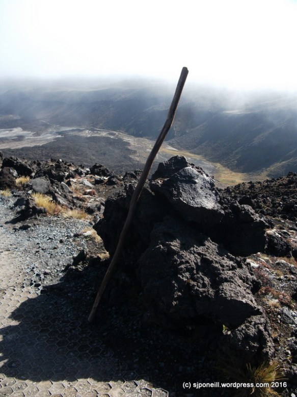
…or to paraphrase Theodore Roosevelt “Tread carefully and carry a big stick“…two concepts directly related to my summit of Mt Ngauruhoe yesterday…
This is Stick. Stick is a little miffed that it missed out on going up Mt Tongariro last week, but that’s kinda what happens when you hide away in a dark corner of the garage. Stick is way more useful than lightweight aluminium walking poles which are too flimsy to brace your weight against. Stick is also really good as a counter-balance and a brace when descending scree slopes…
Tuesday and yesterday offered the best weather windows for another go at Ngauruhoe; yesterday had the least wind and Tuesday was off the list when I remembered that I had to speak to a visiting Duke of Edinburgh group from Karamu School. The day opening with a beautifully clear sunset that boded well for the day’s adventure.
…what would I say to any one venturing into Tongariro National Park for a day walk or an overnighter..? I had been thinking about writing something like this after my Brutal post yesterday but this comment on my Carry a Big Stick post from my last excursion up Mt Ngauruhoe pretty much made the decision for me (thanks, Rob!)…
I would start with the weather. I would say to only check the Metservice forecast for Tongariro National Park. There may be other sites and apps that may tell you want to want to hear but only Metservice has trained meteorologists in the analytical loop. The Metservice forecast for the park is only for five days: three in detail for Whakapapa Village at 1135m and Red Crater at 1868m; the last two days in outline.
Snow in December
Updates are issued each day around 7-30AM and around midday: each update may be quite different from the forecast it replaces. Do not expect the actual weather to always conform to the letter of the forecast. In the end it is your decision to carry on: if you think the conditions are taking you outside your comfort zone (perhaps too hot, too cold, too windy, too wet, too slippery i.e. icy, too cloudy, etc) stop and think about what you are doing and review your options…
The weather here is very changeable so sometimes even the five day forecast is subject the swings of extreme: unlike the South Island which has long mountain ranges that keep the weather pattern relatively stable, our weather can not only switch just like that but can also manifest itself as radically different micro-climates in close proximity to each other..a couple of years back, two inches of hail were dumped at Mangatepopo without even darkening the blue skies over Whakapapa Village…
Regardless of the forecast, be prepared for four season in one day: a good thermal layer and a good wind- and rain-proof layer, gloves and beanie but also sun hat, sunglasses and sunblock; good walking shoes or boots – not jandals or heels; enough water, at least 1.5 litres, for the day and enough food for the day: good snacky energy food…
So what if something happens…?
In New Zealand, cell phone coverage generally follows the highways : Tongariro National Park is sandwiched between four highways and enjoys reasonable but NOT PERFECT coverage – a lot may depend on the specific model of phone and your service provider – if you need assistance, for example, you are lost, injured or assisting someone else, dial 111 and ask for Police – in New Zealand, the Police are responsible for all off-road rescues. Even if it is an injury: if you are off the road, ask for the Police!!
Three safety questions
Regardless of whether you are going out for a day or overnight, there are three questions you need to ask yourself:
Does someone I trust know what my detailed plans are? Contrary to some myths, this does not have to be someone in New Zealand. It is better that it is someone you trust at home than some bloke you met the night before in the backpackers.
Does this person know when I will contact them after the walk to say I am OK? Ideally this would be no later than the night you finish the walk. If your trusted person is overseas, be very clear about whose time zone it is that you will contact them.
Does this person know who to call if I do not return? If they are in New Zealand, they should dial 111, ask for police and say that they have a friend or family member in Tongariro National Park on the XXXX walk, that you did not contact them when expected and that they are unable to contact them. Information that it is good for your trusted person to have ready to pass onto the Police:
Your DOC booking number if you are booked into one of the huts or campsites. If you are just on a day walk, where are you staying that night?
Your car registration number. This allows Police to check cars parked around the Park and also to check to see if you may have left the Park and then been involved in an accident somewhere else.
Your cell number – written out not just as a number in an address book: for when the Police ask for the number.
Your Personal Locator Beacon ID number, if you have one. If you do not, especially if travelling on your own, a PLB can be rented for about $10 from various locations around the Park.
Any medical history you or anyone in your group may have that may affect your ability to complete the walk and/or that may be useful for a search party to know.
It is quite important that your trusted person does not fall into the trap of ‘Oh, I’ll just give it another couple of hours’ or ‘I’m sure they’re OK, I’ll call in the morning‘. If they do not hear from you when they expect to and cannot contact you they should make the call.
If your trusted person does not speak good English, it is a good idea for you or them to write down what they want to say in English so they can just read it out (www.translate.com is your friend)
If you are the trusted person for someone, don’t waste time playing amateur detective trying to find someone. Under New Zealand law, companies and agencies cannot release information on who may be booked with them or not. All you are doing is wasting time – call the Police and let them do this.
New Zealand is a beautiful place and we all want everyone to come here to enjoy it but…
We don’t close things if they might be unsafe: we rely on visitors to make informed decisions against their own experience and equipment. If in doubt don’t…
Don’t believe everything you read on Facebook or hear in the backpackers about what is or is not doable…
Take responsibility for your safety and that of your friends and family…
Have a Plan B…and C and probably D…
There is no view worth a free helicopter ride…
…it’s not actually free…these cost a lot of money to maintain and operate…