Woke up to snow at home this morning…mainly windblown but nice to see it making the effort…slushy snow on Raurimu Bridge and then increasingly realer snow into National Park Village and then down SH47/48 to Whakapapa…
All images (c) sjponeill.wordpress.com
Even though the plough and grit trucks are out, temperatuires are still below zero in most places…with the ski fields and ski field roads being closed, I’d really suggest people want to stay off the roads unless they really need to be somewhere…
Today’s post as been brought to you by the number 4 and the letters W and D…
“…sometimes the measure of success is how well you respond…”
That was my parting shot in The magnificent seven ride again…, the tale of a 2011 pub crawl against a backdrop of NATO’s Libyan ‘intervention’ and the lone wolf terrorist attacks by Anders Behring Breivik in Norway in July 2011.
Five years later, those are still true words although I see response from a different perspective now…once, response was force projection, rapid deployment, targeting; now response is something we manage every day…
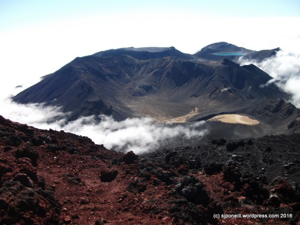
Today’s prompt is disaster…the biggest disaster to hit this region in the last 2000 years was the Taupo eruption around 182-300AD, depending on whose book you read. Of course, if disaster strikes and there is no one there to suffer from it, is it really a disaster or just a large scale natural event..? I mean, we’re talking seriously large scale here: the biggest explosion that the world has experienced in the last two, possibly more, millenia.
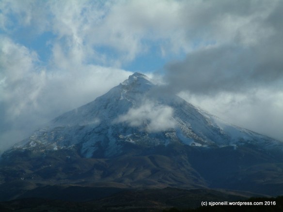
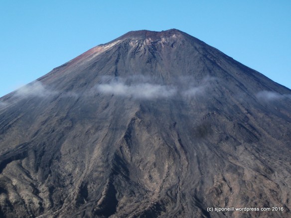
When we talk eruptions here, it is always in the context of when, not if: we know that the three volcanoes – Ruapehu, Ngauruhoe and Tongariro – will erupt again. The iffy bits are when exactly and how much…questions that can only be answered after the fact. Predicting eruptions is much like predicting earthquakes: often we can see a shift from what’s considered normal, maybe an increase (or decrease) in gas emissions, a cooling (or warming) of a crater lake, more (or less) volcanic tremors: but what it means is very difficult to determine.
Because prediction is problematic, a lot of resource goes into response. The timelines are pretty tight. A lahar (big volcanic mudslidey thing) coming down the western side of Ruapehu will hit Whakapapa ski field in about 90 seconds…that’s not enough time to check your phone for directions, call a friend or update your Facebook page about the big black shadow coming down the mountain…part of the disaster response on the ski field is to ensure that people know what to do beforehand…
Further down the the hill, residents of Whakapapa Village have a whole twenty minutes to evacuate everyone from the danger area along the Whakapapanui Stream, essentially the Holiday Park and the housing area across State Highway 48 from the Chateau. Twenty minutes doesn’t sound like much time but after a fortuitous (probably didn’t seem like it at the time) series of false alarms in 2015, Whakapapa residents know they can do this at nine at night, in winter, after dinner and maybe a few beers.
There may be no warning. An eruption may occur on a beautiful blue sky day, or in the middle of a black, freezing, sleeting, icy night. Luck ran twice when the Te Maare craters erupted in August 2012. Lucky once because an eruption at 11-30PM meant there were no walkers on the Tongariro Alpine Crossing as rocks hammered down onto the track. The biggest of these weighed three tonnes, enough to hurt if it landed on your toes. Lucky twice because, even though it was night, the bunk room at Ketetahi Hut was unoccupied as a rock slammed through the roof.
It’s been many years since we have had a disaster in Ruapehu – some tragedies, yes – but the last real disaster in terms of loss of life and damage was probably Tangiwai in 1953. Once of the reasons that we haven’t had any real disasters since then is our ability to respond. The March 2007 lahar had potential – it was certainly much larger – to be as deadly as its 1953 predecessor : that potential was mitigated, some might say neutered, by a effective well-planned, well-practised response. In fact, between exercises and false alarms, the disaster response was so well-practised that when the main event event occurred, it all seemed a bit boring…
So, when you visit our maunga, take a moment to read the signs and be aware of what’s happening, what might happen around you…if you’re here for your fifteen minutes of fame, don’t let it be in 5000 years when some alien archaeologist chips you out of the remnants of the great Whakapapa Lahar…