Solitude | The Daily Post

Write a new post in response to today’s one-word prompt: solitude.

Source: Solitude | The Daily Post

This morning, I had big plans to clean up, do vacuuming and other such boring stuff…the sun streaming in, though, was too much of a temptation and I went off on another wander…this time, a little closer to home, Tupapakurua Falls just up the road in National Park Village…

There is a good, albeit slightly out of date, description of the route on the Taupo Tramping Club site, and also a good summary in the latest version of the DOC Walks in and Around Tongariro National Park (page 24). The track is pretty well-marked and does not pose any great navigational challenges so longs as normal common sense is applied, especially on the leg down to the base of the Falls.

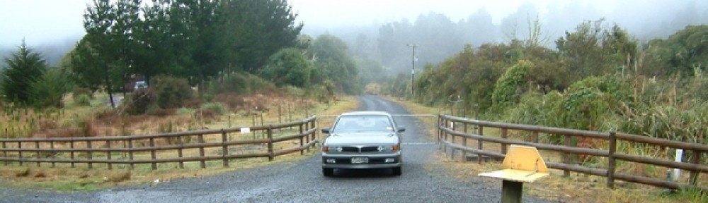
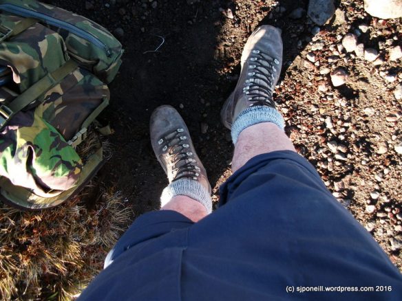
The track starts in National Park Village. Park where you like but you need to be looking at this in Carroll Street to get underway:

DSCF0014

Cross the railway tracks – the BUSY railway tracks so take appropriate care – and follow the road round to the left…DSCF0012 …taking the first right down Fishers Road where…DSCF9968…after a couple of kilometres, you come to the start of the trail proper. Yes, you could just drive here but it’s a nice walk along the road and you wouldn’t want to drive only to find that the freedom campers have taken up all the parking:

DSCF9970

A short way along the track there’s a sign:

DSCF0008

This is a great way for walkers to contribute to the maintenance and ongoing development of tracks like this one: all you have to do is pick up a couple of buckets and carry them to the next bucket depot. Don’t stress: the depots are only a few hundred metres apart and the buckets aren’t too heavy.

DSCF9973

Grab two and start walking…

Along the sides of the trail, you’ll occasionally see traps for rats and stoats. Unless you are part of the community trapping programme, leave them alone…

DSCF9974

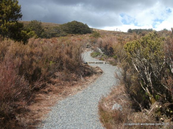
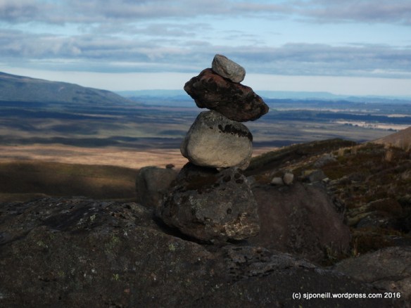
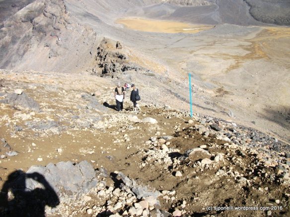
The track is well-marked and very easy to follow; the gradients are all quite gentle and after twenty minutes, I got to the Taranaki Lookout:DSCF9978

…with Mt Taranaki clearly visible on the coast about 120km away…DSCF9976-001

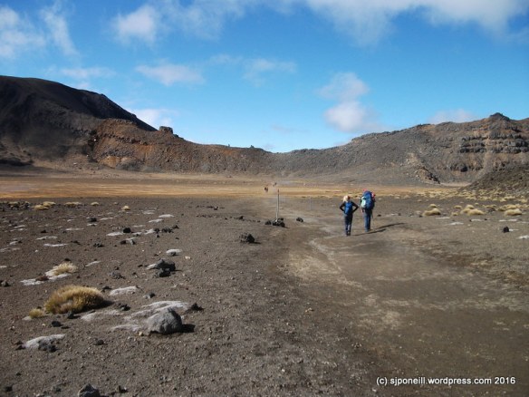
From the Taranaki Lookout to the Tupapakurua Falls lookout is about an hour of easy walking. The track is not quite so well-defined, marked or developed and there are a few roots and other potential hazards for the carelessly-placed foot. The climbs are a little less gentle but still doable for walkers with average health and fitness: just take care where you are placing your feet. This is original New Zealand rain forest that does not get a lot of sun through the canopy – the sort of environment over which Von Tempsky pursued Tītokowaru – smooth surfaces, wood and rock, can be slick and slippery: there is no cell coverage here and even satellite access can be dodgy at the bottoms of the canyons: if you are on your own you may have a long wait for assistance if you have a whoopsy.

DSCF9984 
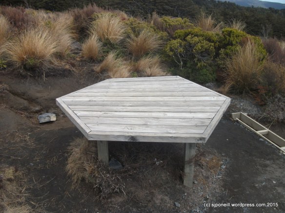
The lookout is a nice spot for the break…DSCF9980 …with good views of the Falls in the distance.DSCF9985

The Taupo Tramping Club notes recommend pushing a few minutes south-west of the lookout to the end of the ridge for a better view of the Falls and the valley. I really recommend doing this as the views are much better. Not mentioned in the notes is the more-recently developed track down to the base of the Falls. I almost gave this a miss as my destination for the day had been the Falls lookout but it was still morning, still sunny and I had come all this way…I’m glad I did as it was the highlight of my walk!!

The track down to the base of the Falls is marked with the standard blue poles and orange arrows. It is not nearly as well-marked as the track to the lookout and walkers really need to be able to see the next marker before stepping off: there are many animal and hunting trails here as well and it is so very easy to follow what you think is the trail and find yourself geographically-embarrassed with no clue as to how to get back onto the actual trail…

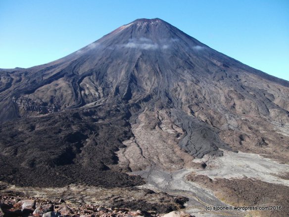
Having said that, I found myself at the base of the Falls after a descent of around 15-20 minutes. Wow!! I need a better camera with a decent wide-angle lens to capture scenery like this…

The sun only gets into the valley later in the afternoon and it was not at all warm down in the base of canyon, plus the Falls throw up a fine mist that further drops the temperature: definitely NOT the spot for lunch..(or a swim!!)! But very much worth the extra walk and really made my impulsive activity worth the undone housework…

The climb back up to the lookout was not as arduous as I thought it might be on the way down BUT you do have to take care that you are actually on the trail as I found a couple of times

I still wasn’t that hungry when I got back up to the Falls lookout so pushed on back to the Taranaki lookout. I still wasn’t that hungry but felt I should eat something since I had carried it all this way: lunch was my standard walking lunch of a bannofee smoothie – tastes a lot more bananary with fresh bananas – and a couple of Jen Rice’s chewy spicy apple cookies – I always carry more but, as advertised, two is enough for a quick meal on the go.

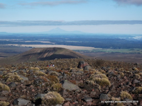
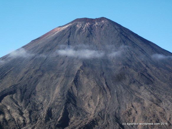
From the lookout back to Fisher’s Road was only about ten minutes. Walking back down the road, I was welcomed back by a spectacular view of Mt Ruapehu through the trees…

DSCF0010

My total time for this walk was just under four hours: obviously I could trim this down quite a bit if I wanted but what would be the point. This is the first walk that I have done in this series where it was just me and the outdoors – solitude – and it was there to enjoy. The last two adventures that I have done, on Tongariro and Ngauruhoe, have been in open terrain and I was surprised just how comfortable I felt today returning to the close country of my roots…oddly, although was was the least strenuous of my three adventures to date, it is the only one that has left me with quite sore shoulders…really wish that I had that spa pump repaired now…

Carry a big stick…

…or to paraphrase Theodore Roosevelt “Tread carefully and carry a big stick“…two concepts directly related to my summit of Mt Ngauruhoe yesterday…

SCF9964

This is Stick. Stick is a little miffed that it missed out on going up Mt Tongariro last week, but that’s kinda what happens when you hide away in a dark corner of the garage. Stick is way more useful than lightweight aluminium walking poles which are too flimsy to brace your weight against. Stick is also really good as a counter-balance and a brace when descending scree slopes…

SCF9924-001

Tuesday and yesterday offered the best weather windows for another go at Ngauruhoe; yesterday had the least wind and Tuesday was off the list when I remembered that I had to speak to a visiting Duke of Edinburgh group from Karamu School. The day opening with a beautifully clear sunset that boded well for the day’s adventure.

Mt Ngauruhoe (thrower of rocks) is technically ‘only’ a vent on Mt Tongariro but because it is now higher than its parent and such a prominent feature, it is counted as a mountain in its own right. Don’t be fooled however, it is still an active volcano and carries with it, its own unique hazards: it is very steep (a consistent 30 degrees), very smooth and covered in loose rock.

SCF9925

It was pretty brisk at Mangatepopo car park with the normal number of Alpine Crossing walkers milling around. The sky was clear, and the sun beaming down but the temperature was barely above zero…the best way to keep warm: get moving…

Many walkers were way over-dressed and already shedding layers in the first couple of kilometres…a number, by Soda Springs, were already quite oblivious of their surroundings and had to be asked to allow faster walkers past…I don’t really see the point of doing a walk like the Crossing if you are going to zone out before the end of the first leg…

SCF9929

A decent frost crisped up parts of the track lying in the shadow of Mt Tongariro, a good reminder that winter is drawing closer and with it, winter ground conditions. Although there was quite a bit of frost on the board-walks, they weren’t slippery but that won’t be too far away…DSCF9893

I made good time up to the top of the Devil’s Staircase, about 90 minutes. At this sign, turn right…in summer ground conditions, i.e. no snow on the ground, a trail has been worn from the sign towards the base of the volcano.

SCF9963

We’re not kidding!!

Because the sides of Ngauruhoe are so steep and smooth, any rocks knocked loose – and many of the surfaces aren’t that stable to start with – can roll hundreds of metres, picking up a lot of speed along the way. On my way up, I saw two torso-sized boulders crashing down the scree slopes: if they collected anyone on their way down, the results would be serious injury and a free helicopter ride…

SCF9938

As this peters out, a series of blue and orange track markers indicates the route to the beginning of the real climb…

The trick to a safe and successful ascent of Ngauruhoe is to work your way up the solid rock formations, avoiding the scree slopes as much as possible: they are really hard work going up and unstable to such a point that upwards motion, slipping and sliding, will generate lots of mini rock slides.

As a very young volcano, a lot of the rock on Ngauruhoe is very rough and sharp and this is more pronounced the closer to the summit that you get. Hard shell gloves are a good idea – your nice wool Icebreaker gloves will last about five minutes – and I’ll be digging out my leather shooting gloves before I come back up here.

Another incredibly highly recommended piece of kit for Ngauruhoe is a climbing helmet. Unless you are fortunate to strike a day when you have the mountain to yourself (unlikely to occur with decent weather conditions), there is a consistent trickle of small (and not so small) rocks coming down from climbers ahead of you. In addition some of the rock faces on the way up are quite steep with potential drops of a few metres: you may be the best rock scrambler in the world, the that mightn’t help you if you get wiped out by someone less experienced ahead of taking a tumble.

climbing helmet

Something like this…

…and, no, I didn’t wear a helmet myself…something that a. my school group from Karamu School called me on when I caught up with them at Soda Springs on my way back and b. that I intend to do something about before I return…I only saw one group up there with helmets but lots of near misses…

Stick was really useful as a brace on the ascent and there was only one time where I needed to use both hands for climbing…everybody that I saw with walking poles struggled with them: they are too flimsy to be used as a brace and, more often than not, tend to just get in the way: you do need at least one hand free for climbing. I carried a set of poles up for a young American lady who had come expecting a walk not a climb and who was reduced to throwing her poles ahead of her as she used both hands to climb…

This young lady had also been left behind by the rest of her group which is pretty untidy – if you start as a group, you go as a group and finish as a group – more so, when she did not have any water on her. I carry heaps and was happy to share, bolster her confidence and encourage her to the summit but she was not prepared for this sort of activity and was having a pretty miserable time – which defeats the whole point of doing things like this…

SCF9943

It took me about two hours to the summit: spectacular views!! But all that rock is very hard and very sharp with a some big potential drops of the unwary or unsteady of foot..

SCF9948

The top of the cloud was sitting around 1400 metres but all the good stuff was visible, looking here across Red Crater to Blue Lake; lower centre, you can see the Tongariro Alpine Crossing heading up towards its highest point of 1868 metres, and the trail to the summit of Mt Tongariro. climbing off to the left…

SCF9939

There are active vents (fumaroles) on Mt Ngauruhoe and steam was clearly visible from this one on the summit: you can just make it out at four o’clock from the left-hand figure on the skyline…

SCF9949

Without wanting to repeat myself, this volcanic rock is hard and sharp…about three steps into my descent, I slipped and slip a couple of metres and have some nice skin to grow back on my left wrist…slow and steady is the way…

SCF9956

The easiest and safest way to descend Mt Ngauruhoe is down the scree slopes to the west of the rock that you climbed up on. Avoid the rocky surfaces: they are not very stable and you WILL set off rock slides!! Stick to the channels of already disturbed scree where there are less rocks.

SCF9954

Stick was really useful for bracing myself on the scree…this is soft and loose…if you are wearing ankle boots or runners/trainers (really?), gaiters would be a good idea as you will be sinking into this stuff up to and over your ankles. Don’t be an idiot and leap your way down the scree slopes: not only are you kicking loose a lot of loose material that hazards those below you, but if you strike a fixed rock beneath the surface, you are likely to lose your balance and become your own rock slide…you can descend quickly and safely without being an idiot…

Be aware of your surroundings…I spent a lot of my descent time watching behind me for rocks knocked loose by other people…not everyone calls ‘rock’ when they set one loose…think a couple of steps ahead as to where you will go if a rock comes in your direction…

Mt Ngauruhoe Summit climb April 2016 -026

…and finally back on the trail just before the junction with the Alpine Crossing…I was tempted to carry on up to Red Crater, across to Mt Tongariro and come back down the way I went up last week but I didn’t fancy descending down through that cloud on an unmarked trail…

Mt Ngauruhoe Summit climb April 2016 -028

A final shot from just short of Mangatepopo car park…perversely the view was clear with that little cloud rolling in in the time it took me to get out my camera…

Total time was about 6 1/2 hours but that includes a decent break for lunch, assisting the young American lady and stopping to talk to groups along the way. My total walking time, with just breather breaks would have been in the region of 5 1/2 hours…

Insights

  • Gloves – a good set of well-fitting leather gloves will save you skin
  • Helmet – may save your life.
  • Decent sturdy footwear – not runners! Consider gaiters to keep the scree out of your boots/shoes.
  • If you must take walking poles: either take only one of have a backpack that will let you carry them if you don’t need them.
  • Tread carefully: be sure you are stepping onto firm ground before you transfer your weight…
  • Jeans make the climb – and it is a climb not a walk – hard work. I was comfortable in shorts and an Icebreaker T-shirt all day BUT I had good clothing for cold/wet weather on me if I needed it…

BE AWARE OF YOUR SURROUNDINGS – YOUR SAFETY IS YOUR RESPONSIBILITY!!!

It was disappointing to observe the number of people who were physically and psychologically unprepared for Mt Ngauruhoe…many thought it was just a walk and struggled with the climb and the height – one loud American complained the whole way up about his fear of falling – others got up all right but had no idea how to get down…here’s a hint: it’s easy to climb UP the rock; climbing down the same way is not nearly as easy and you’re making people still coming up work around you…

This, I think, puts a lot of the responsibility back onto us locals to ensure that we are setting visitor expectations appropriately in all our contact with them, and through our websites, and social media engagement…Mt Ngauruhoe is not a place where ‘just do it’ is a good or safe philosophy…


Fog | The Daily Post

Today’s one-word prompt: Fog.

Source: Fog | The Daily Post

Clouds can form at many different altitudes. They can be as high as 12 miles above sea level or as low as the ground. Fog is a kind of cloud that touches the ground. ~ SciJinks

These one word prompts from WordPress always strike me as quite lazy: if the muses can’t be bothered putting any effort into the prompt, I feel less inspired to apply myself to any response…all too often my response is graphic (graphic imagery-wise, not graphic colourful in the semantic sense!) but while I am set-a-foot for the next week or so, I’m determined to write something once a day, even if it is not in response to that day’s prompt….

Fog here, just is…it is more common than not in the morning, often beautifully so, filling in the low ground and giving rise to impressions of great inland lakes, around which the road skirts – or sometimes descends into…

Raurimu-010

On the mountains, it is common for fog to form rapidly, catching out the unwary walker or climber. Often visibility will deteriorate to a point where the next marker pole on a track is no longer visible; or the landmark you are using as a point of reference of exploring off-trail just disappears…

DSCF9856

It is actually quite cool to be sitting up high and watching clouds and fog form in front of you, or below you…often around mid-morning as the sun burns off dew on the rocks from the previous night, the water vapour created will only rise a few metres and then drift off, slowly (sometimes not too slowly) thickening into a thick mist…

DSCF9864

Sometimes it is only a matter of minutes before clear skies are obscured, and navigation is hindered + it is cold in the cloud as well: another trap for the unwary…

DSCF9865

…and from there to here, on the summit of Mount Tongariro, where walkers are wisely waiting for the fog to clear enough for the poles marking the trail back to Red Crater to be visible again…it normally doesn’t take too long…best to wait than to wander off and find you cannot see any sign of civilisation when the fog clears..!


Tongariro – the back way

Wow! I haven’t had such a good day on my own for a long time…

I have two weeks off to consume accumulated public holidays and time in lieu…with three days of fine weather forecast this week, normally I’d be working on the Lodge but this week I’m letting my muse drive me…

Today – and I am trying to write this while the memories are fresh and before I face-plant the keyboard as I am  just a little jaded – to venture up the ‘alternate’ route up to Mt Tongariro from Mangatepopo, across to Red Crater and then back down the Crossing trail to Mangatepopo. It’s probably a by-product of my green journey and its muse that I feel attracted back to the outdoor environment; that, and wanting to get some me time away from people ( natural enough when you work with hundreds of visitors every day).

An early start to make sure I could get a park at or near the Mangatepopo car and I was legging it towards Mangatepopo Hut by 7-30. No pix of the car park: although it wasn’t nearly as chaotic as it can be there were still heaps of people milling around and I just wanted to get underway.

The hut is only about fifteen minuets from the car park. I made a quick stop there to enter my trip into the hut book – you can never be too careful – and away I went…

DSCF9841

Mangatepopo Hut

There is quite a well-formed track that heads off north-eastish from the hut down to the stream. Some parts of the track towards the stream are quite heavily eroded and you need to be a little careful especially when it is a bit damp/slippery, as some of gouges are a metre or so deep. I followed that across the stream and up the opposite slope where the track is still pretty clear. From the sign it is fairly well-used.

DSCF9849

Target for today: Mount Tongariro

The climb up is pretty easy but already the day was warming up well past the forecast 0-5 degrees.

DSCF9852

I had dressed for the the forecast and was already feeling a tad warm so converted my trousers into ‘shorts’ with some judicious folding. Much more comfortable.

DSCF9845

It looks pretty but…

Why do people persist in build cairns in the Park, especially things like that that are purely decorative? Do they not get that it is a national park and the whole is to do no harm. The environment here is very delicate and even moving one rock exposes fresh soil to the elements and leads to the erosion that already devastates parts of the Park.

DSCF9850

Oh, great, people!!!

I was looking forward to some quiet introspection time so the sight of a group following me up was not welcome. I stopped to let them pass me but we ended up pacing each other and then travelling together. They were a group of Duke of Edinburgh students from Thames High School whose objective this week was four summits in four days. They’d missed out on Ruapehu two days previously as the weather had closed in and they’d decided to pull the pin – good move – but had summitted Taranaki and Ngauruhoe successfully.

DSCF9853

The lava flows from the more recent eruptions on Mt Ngauruhoe are very clear from across the valley. When (not if) Ngauruhoe erupts again, the historical lava route has been down the north-western slopes and we’ll need an alternative route like the one I walked today to keep the Tongariro Alpine Crossing open.

You can also see cloud forming off Ngauruhoe as the morning sun evaporates dew off the rocks. The same thing was happening on the other side as we walked up. Many people are surprised by just how quickly cloud can form up here and how thick it can be. As people found once we were on the summit, when the cloud is so thick that you can see the trail properly, the best thing to do is just sit it out.

DSCF9857

How erosion starts 101

I encountered a number of gouges in the surface like this as I climbed further up. There were clearly man-made as some of them ran perpendicular to the flow of water off the slopes. Some of them looked like campers had carved out a little drain to divert water around their campsite; others looked like rocks had been rolled or dragged down the slope. The surface up here is that delicate that interference like this will channel rainwater and cause serious erosion in a very short time.

There is not a trail all the way to the summit but the route is fairly intuitive with only one significant scree slope just below the summit. The trick is to aim slightly left as you approach the peak and this will take to directly to the summit. The climb itself is pretty Goldilocks: not so long that you get into ‘are we there yet?’ syndrome but not so short that you don’t feel like you haven’t done any work. Cresting the summit is really “OMG, we’re here!!”

DSCF9863

Thames High DofE group


DSCF9864

The cloud closed in as soon as we reached the summit…

…restricting views to just the top of Ngauruhoe.

DSCF9861

Lunch

Lunch for me was one of my bannofee smoothies and a couple of Jen Rice’s chewy apple spiced cookies – Jen says that two of these cookies are a meal and she is absolutely right: even after walking for three hours, two were more than enough to fill me up. I would have brought one of her turmeric coconut and pineapple smoothies except I’m out of pineapple until my next trip to civilisation.

DSCF9867

As I finished my lunch the cloud closed right in…while we waited for it to clear as it usually does relatively soon, I enjoyed talking with other waiting walkers about the Park, Lord of the Rings – always a safe subject – and the volcanoes.

DSCF9866

A minute ago this was all cloud

Even quicker than it had appeared, the cloud disappeared and it was off down the marked trail to Red Crater

DSCF9882

Skirting around the rim of South Crater down to Red Crater…

DSCF9880

Looking down into Red Crater

Most Crossing walkers had already passed this point so I didn’t encounter too much traffic in the other direction heading down towards South Crater

DSCF9885

Enter a caption

A late walker heading up to Red Crater…the route is quite steep and uneven but easily negotiable in either direction so long as walkers take care and watch their foot placement.DSCF9887

Looking back across South Crater: the route up to Red Crater runs about halfway up the ridge line that runs out the left edge of the image…

DSCF9896

Looking down from the top of the Devil’s Staircase, over Soda Springs to the beginning of the Crossing. Mangatepopo Hut can just be made out centre left. The route down the Staircase is quite windy but easily negotiated at speed over most of its distance.

DSCF9904

From Soda Springs to the hut is very flat with many ‘highway’ quality board walks. I always hate this leg as it is, IMHO, quite boring and rather administrative in nature.

Today was the first time that I have been out in the Park for a couple of months. Although the solitude was not as I expected, I enjoyed meeting and talking with other walkers and exploring a path less travelled.

DSCF9856

Target for tomorrow..?

That will probably depend on whether I can get out of bed in the morning…some joints are having a bit of a bitch tonight…

Seasons | The Daily Post

This week, let’s embrace the season: share an image that embodies the world or the weather where you live.

Source: Seasons | The Daily Post

Every January, the Department of Conservation and Project Tongariro host the local Mahi Aroha Summer Programme, a month-long calendar that encourages people into the outdoors and showcases local conservation projects…DSCF9471The first activity each year, on New Year’s Day, is the family kite day…
DSCF9481Even though the first of January is technically in the middle of summer, true summer here often does not kick in until February….
DSCF9486Pleasant but overcast days like this are common for this period of the season…DSCF9476

…and are no obstacle to everyone getting out and having a good time…DSCF9487

A bonus this New Year’s Day, was the first mistletoe in Whakapapa Village…

Ridge Track, Whakapapa Village

The Ridge Track is a nice short – about twenty minutes/1.2km each way – walk right in Whakapapa Village…great for a quick leg stretch at lunchtime…

DSCF8850

It starts here at the public shelter, just up the road from the DOC Visitor Centre, and opposite the Whakapapa Holiday Park. The trail itself is just up from the shelter , where you can see the DOC sign on the right of the picture…

DSCF8849

The trail winds behind the shelter…

DSCF8848

…across the bridge and into the forest…

DSCF8847

…past a nice resting spot about halfway up (the forested part)…

DSCF8846

…before you break out into the open and continue up through the tussock.

DSCF8845

Not all of the trail is in tiptop condition and sections like this can be a little more challenging, especially after a good downpour…

DSCF8843

…and your’re there…

DSCF8844

No one is quite sure why there is a big table here but there is…be nice ofr a picnic, better if there were seats…

DSCF8838

Further up the ridge line, on a clearish day, you can often see the very top of Mount Ruapehu…

DSCF8839

…to the north, there are often great views of Mount Ngauruhoe and Mount Tongariro…

DSCF8841

…and below, The Chateau and Whakapapa Village, with SH48 winding back down towards SH47 and civilisation…

Tea and Pikelets at Waihohonu

A change is as good as a holiday, so they say…and I leapt at the chance to get out of the office to check on internet connections in the huts on the Northern Circuit.

My day didn’t get off to the smoothest of starts…

DSCF9332

Naughty Meindls

…my trusty Meindls tossing a lace…already running a tad late, I grabbed…

DSCF9333

Good Meindls

…my spare never-before worn pair…the beauty of Meindls being that you really can wear them right out of the box…

DSCF9322

Looking east towards Red Crater, Mount Ngauruhoe on the right

It doesn’t look like the cheeriest of days but it was actually a great day for walking, a nice westerly to take the edge off and keep us cool, and just enough sun to be pleasant without being scorching…

DSCF9321

First stop was Mangatepopo, only about twenty minutes walk in from the car park…a nice cuppa with the ranger there…

DSCF9324

…before some comparative performance testing on laptops, tablets and phones…

DSCF9330

Lured by the promise of pikelets for smoko, we headed off for the other side of Mount Ngauruhoe and Waihohonu Hut…Parking up at the Waihohonu Road End park we made good time into the hut. The surface is mostly sandy, firm enough to walk on but not so compacted as to be uncomfortable…

DSCF9326

While we did our techo-geeky stuff…

DSCF9329

…the chef started on smoko…

DSCF9325

Who says you can’t have the comforts of home in a back country hut..?

DSCF9328

As you can guess from the pix, Waihohonu is quite new and very comfortable…

DSCF9330

Seeing the cloud spilling over Ngauruhoe, we decided on a more cracking pace back to the park, completing the last klick or so at an enjoyable jog…

I’m regretting not filling the spa a couple of weeks ago as a nice soak would go down pretty well at the moment…I suspect that I may be a little stiff in the morning…a most excellent day and one I hope to repeat next week as Oturere still needs testing….

Ornate | The Daily Post

In your photo this week, share something unabashedly ornate — where it’s clear that the creators pulled no stops and went all out.

Source: Ornate | The Daily Post

I layed-over in Philadelphia for a couple of nights between conferences on my 2011 American Odyssey tour. I was most excellently hosted by Doc Karma, taking a day off from his plans for world domination (they still need a little work as they hinge on his invasion forces walking to New Zealand).

USS Olympia is tied up there, opposite the New Jersey…I was fascinated by the contrasts in decor between one of the first modern ironclads and one of the last. ornate, most definitely. Over the top…nope, just the standards of the time…

DSCF2165

Wheelhouse

DSCF2148

Wardroom

DSCF2155

Even the armament has an ornate steam-punky arty feel to it…

Off-Season | The Daily Post

Umbrellas in winter? Balaclavas in July? Show us what “off-season” means to you.

Source: Off-Season | The Daily Post

DSCF8861

We’re a little lucky here, that we don’t really have much of an off-season…maybe three weeks between the end of the ski season and the start of the summer season; and May and June can be pretty slow as well once the Great Walks end and the uncertainty over first snow begins for another year…

In winter the main street in ‘town’ is fully of cars either heading up to the ski field or trying to head up to the ski field is the road is closed or restricted to vehicles with chains or 4WD (pull up a chair to observe case studies in crowd behaviour!); playing in snow on the side of the road; wandering in and out of the cafes…

In summer, it’s much the same…less but not necessarily no snow…this clip went viral from the Park Facebook page as it snowed heavily on the first day of summer last year…

…but generally summer = as many, if not more, visitors, less clothing and more sun…

Summer 2014 started for us in October with a brill period of beautiful summery weather as the Great Walks opened…the first day that it was so hot we opened all the doors and windows, it started to snow…the biggest dump of the winter and we were back to winter for six weeks…six weeks where five of six Wednesdays it snowed heavily in the Village…six weeks of chaos as we shuffled, cancelled and refund Great Walks bookings…six weeks of the most intense staff training as we brought a 90% new crew up to speed…

The autumn (fall) off-season is a little more stable, consistent but no less intense…it is our main window of opportunity for maintenance, stocktakes, product development, updating brochures, possibly even a little leave, training, strategising, sometimes even just relishing the opportunity to put our feet up for a few minutes and talk ‘stuff’…

…and then the snow falls and it starts all over…

It only works with a great team…proof that paying peanuts doesn’t always get you monkeys…

Jandalman and the Tongariro Alpine Crossing – a cautionary tale

By now some of you may have heard the tale of Jandalman, or seen it on some of the local guiding Facebook pages and sites. The story has been hammered pretty hard locally to get the mountain safety message out there…

This is the tale of the tourist who was found on the Tongariro Alpine Crossing a week or so ago, trying to walk out in bare feet having lost his jandals in the snow (yes, you did read that right!). Of even greater concern was that the same guiding parties turned back four other similarly ill-equipped (at least they had shoes) walkers after this.

Jandalman

Jandalman, in black, sitting on the blue thermal mat, being worked on…

This is the story as posted.

“…TOURISTS – PLEASE USE THE RIGHT GEAR AND GUIDES

This guy missed out on his Darwin Award this weekend…… by an ultra slim margin.
We found him on the Tongariro crossing, he attempted it in Jandals (thongs, Flip Flops), that jacket and jeans. Lost his jandals and jumper in a fall, what a surprise, No gloves, no hat, no food, no water, no over trousers, no map, no compass, solo attempt etc. …

When we found him he was on his way down, trying to get to his car in bare feet (He had made it to the top and fallen down Red Crater I think) and having fallen his hands were well cut up. His brain had switched to survival mode and he was focused on walking the last 5+ km of snow, ice and sharp volcanic rock to his car.

NOTE TO REMEMBER – His brain was so focused on survival, survival instinct kicked in, that I had to insist he stopped and let us help him. He was initially refusing help.

Stopped him, gave him warm chocolate drink, bandaged his hands, put socks on feet and hands and then another Kiwi party came down (also dragging down with them two more terrified, bleeding, Frenchmen who at least had sneakers on, not much use). A member of this other Kiwi group had a spare set of boots and agreed to take our guy down as well so that I could carry on.

Had to put the boots on him, he could not do it for himself.

Had to fix his hands, he could not do it for himself.

We then started up again and found two more idiots coming up behind us, also in jeans, sneakers etc. We turned them around too, they were Polish.

This guy is from France. Very close to being “…his name WAS from France…”

It is quite scary that people are still regularly ignoring or not even seeking the advice available from I-Sites and DOC Visitor Centres, and that there remains a strong perception that the mountains are safe and benign environments. Many of them only here what they want to hear and so the slightest hint that a walk may be walkable is all they need to start off. Even after being warned about winter conditions on the Crossing, a number still try to bluff their way through although many are stymied when shown a picture and asked to point to the crampons.

To assist with education and information on conditions and activities around the Park, DOC has established a Facebook page on which its posts updates on daily conditions around the Park.  So if you’re visiting, maybe check this before you head off..? A free helicopter ride is not all it’s cracked up to be…